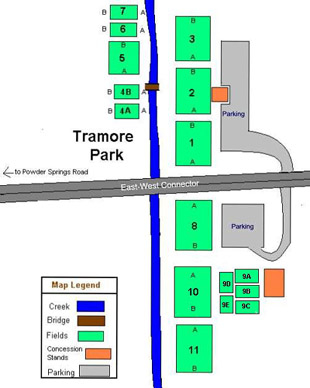
Tramore Park
2150 East-West Connector
Austell, GA 30106
field status: 678-318-3622 (or use host club hot-line)
field layout: click link
Tramore Park is a large soccer park on the East-West Connector between Powder Springs Road and Austell Road in southwest Cobb County. The park has concession and restroom facilities on site.
Driving alerts:
- The map doesn’t make it clear, but the park has soccer fields on both sides of the East-West Connector. The driving directions below will help you get to the proper entrance and field.
- Tournament weekends: Parking is usually a big challenge. Allow more time than usual. It’s not unusual during tournaments for cars to park on the shoulder of the East-West Connector. We don’t recommend this, we just want you to be aware of the situation.
- If you get stuck parking on the wrong side of the East-West Connector, there’s a footpath under a bridge that lets you walk from one side of the park to the other without having to dodge cars. See the field layout section below for more details.
Driving time is approximately 30 minutes from both Metro North Park and United Quest Park. There are three popular ways to get there:
From the I-75 / Delk Road interchange
- Take I-75 to exit #261 (old exit #111): Delk Road/Highway 280.
- Go west on Delk Road toward Dobbins AFB / Lockheed. Stay on Delk Road for 5.1 miles past the I-75 interchange. The road name changes to South Cobb Drive. You’ll pass Lockheed. You’ll pass under the Atlanta Road bridge. When you see a McDonald’s on your left, you’re about a half mile from your turn. You’ll start to climb a large hill.
- Turn right at a traffic light onto Austell Road (shown as Hwy 5 on the map). This is a large intersection.
- Stay on Austell Road for 5.7 miles. You’ll eventually get into a “fast food row” area, and you’ll see Wellstar Cobb Hospital (name may have changed, but it’s the only hospital around). You’re close to your turn.
- Turn right at a traffic light onto the East-West Connector. This is a huge intersection.
- Go 0.9 miles to a traffic light at the entrances to Tramore Park. If you’re on fields 1-7, get into the right lane. If you’re on field 8 or higher, get into the left lane.
- Tramore has entrances on both sides of the East-West Connector; see the field layout below for specific field information. (You’re coming in from the right side of the field layout map.)
Through downtown Marietta
- Take Powder Springs Road west from the Marietta Square area.
- Stay on Powder Springs Road for 7-8 miles. You’ll pass the Marietta Conference Center, County Services Road, Cheatham Hill Road and Macland Road (a large 3-way intersection about 2.5 miles from your next turn).
- Turn left onto the East-West Connector / Barrett Parkway. This is a very large intersection. There’s a gas station / convenience store on the near left side and a Waffle House on the far left side of the intersection.
- Go 1.1 miles to a traffic light at the entrances to Tramore Park. If you’re on fields 1-7, get into the left lane. If you’re on field 8 or higher, get into the right lane.
- Tramore has entrances on both sides of the East-West Connector; see the field layout below for specific field information. (You’re coming in from the left side of the field layout map.)
Through West Cobb
- Take Barrett Parkway (also called Ridgeway) west toward Dallas Highway (Hwy 120).
- Stay on Barrett past its intersection with Dallas Highway for an additional 7.3 miles. Some maps may show Barrett being called West Cobb Parkway or the East-West Connector.
- During this stretch, you’ll cross a large intersection with Macland Road, pass the Mud Creek soccer park, then cross through a major intersection with Powder Springs Road (there’s a gas station / convenience store on the far left side and a Waffle House on the far right side of this intersection). You’ll also pass Marathon Park.
- After you pass through the Powder Springs intersection, you’ll want to pick the proper lane. If you’re on fields 1-7, get into the left lane. If you’re on field 8 or higher, get into the right lane.
- Tramore has entrances on both sides of the East-West Connector; see the field layout below for specific field information. (You’re coming in from the left side of the field layout map.)
Field layout
 Tramore Park has entrances and fields on both sides of the East-West Connector.
Use the main entrance on the east side (top of map) for Tramore fields 1-7. This is the old entrance; it has a standard Cobb County Parks & Recreation sign.
Use the new entrance on the west side (bottom of map) for Tramore fields 8 and above. This is a shared entrance between Tramore Park and an apartment complex.
If you use the wrong entrance, you can still reach your field without driving or risking getting run over. There’s a sidewalk that runs parallel to the creek, under the East-West Connector. Use the sidewalk to get from one side of the park (fields 1-7) to the other (fields 8 and above) or vice versa.
